![](/images/other/stat-length.png)
![Randonnée Marche Ponta do Pargo - MADERE / PONTA DO PORGO 29 06 21 (Rother n° 57 Top) 14 KM - 19 KE - Photo](https://media.geolcdn.com/t/1900/400/ext.pjpeg?maxdim=2&url=https%3A%2F%2Fstatic1.geolcdn.com%2Fsiteimages%2Fupload%2Ffiles%2F1553511878bg_sport_marche.png)
MADERE / PONTA DO PORGO 29 06 21 (Rother n° 57 Top) 14 KM - 19 KE
Vacances
Tracés randos
![Longueur](/images/other/stat-length.png)
Longueur
13,6 km
![Altitude max](https://static1.geolcdn.com/siteimages/upload/files/1508320355ic_sort_altitude_max_24dp.png)
Altitude max
670 m
![Dénivelé positif](https://static1.geolcdn.com/siteimages/upload/files/1508320355ic_sort_den_pos_24dp.png)
Dénivelé positif
575 m
![Km-Effort](/images/other/stat-length.png)
Km-Effort
21 km
![Altitude min](https://static1.geolcdn.com/siteimages/upload/files/1508320355ic_sort_altitude_min_24dp.png)
Altitude min
398 m
![Dénivelé négatif](https://static1.geolcdn.com/siteimages/upload/files/1508320355ic_sort_den_neg_24dp.png)
Dénivelé négatif
575 m
![Boucle](https://static1.geolcdn.com/siteimages/upload/files/16400158638029165_repeat_loop_refresh_sync_direction_icon.png)
Boucle
Oui
Date de création :
2021-06-29 09:03:06.103
Dernière modification :
2021-07-01 18:20:17.124
![Marche](https://static1.geolcdn.com/sitytour/trail-icons/101.png)
3h56
Difficulté : Moyen
![Scannez ce code QR pour ouvrir la randonnée dans l'application SityTrail](https://capi.geolives.com/qq0zvz2zws4bq2lad0pu/sitytour/trails/2844386/qr.png?size=200)
Application GPS de randonnée GRATUITE
À propos
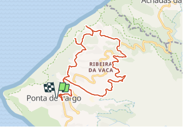
Randonnée Marche de 13,6 km à découvrir à Madère, Inconnu, Ponta do Pargo. Cette randonnée est proposée par Vacances.
Description
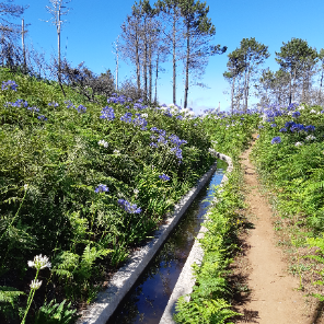
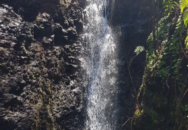
TB rando alternant des paysages très différents Très bon restau (O'Forno)
Pb de calcul de dénivellé -> D exact = 460m
Localisation
Pays :
Portugal
Région :
Madère
Département/Province :
Inconnu
Commune :
Ponta do Pargo
Localité :
Unknown
Départ:(Dec)
Départ:(UTM)
289638 ; 3632773 (28S) N.
Commentaires
Randonnées à proximité
![Randonnée Marche Achadas da Cruz - Levada des moines 1 - Photo](https://media.geolcdn.com/t/375/260/506965b5-7320-4f40-83cd-04bcab3a4c51.jpg&format=jpg&maxdim=2)
![Marche Marche](https://static1.geolcdn.com/sitytour/trail-icons/101.png)
Levada des moines 1
Marche
Moyen
Achadas da Cruz,
Madère,
Inconnu,
Portugal
![](/images/other/stat-length.png)
8,9 km | 12,7 km-effort
2h 53min
![](https://static1.geolcdn.com/siteimages/upload/files/16400158638029165_repeat_loop_refresh_sync_direction_icon.png)
Oui
![Randonnée Marche nordique Ponta do Pargo - Ponta do Pargo - Photo](https://media.geolcdn.com/t/375/260/ext.jpg?maxdim=2&url=https%3A%2F%2Fstatic1.geolcdn.com%2Fsiteimages%2Fupload%2Ffiles%2F1545311037marcheuse_200dpi.jpg)
![Marche nordique Marche nordique](https://static1.geolcdn.com/sitytour/trail-icons/102.png)
Ponta do Pargo
Marche nordique
Très facile
Ponta do Pargo,
Madère,
Inconnu,
Portugal
![](/images/other/stat-length.png)
15,1 km | 24 km-effort
4h 49min
![](https://static1.geolcdn.com/siteimages/upload/files/16400158638029165_repeat_loop_refresh_sync_direction_icon.png)
Non
![Randonnée Marche Ponta do Pargo - madere - Photo](https://media.geolcdn.com/t/375/260/ext.jpg?maxdim=2&url=https%3A%2F%2Fstatic1.geolcdn.com%2Fsiteimages%2Fupload%2Ffiles%2F1553511878bg_sport_marche.png)
![Marche Marche](https://static1.geolcdn.com/sitytour/trail-icons/101.png)
madere
Marche
Difficile
Ponta do Pargo,
Madère,
Inconnu,
Portugal
![](/images/other/stat-length.png)
8,7 km | 15,5 km-effort
6h 17min
![](https://static1.geolcdn.com/siteimages/upload/files/16400158638029165_repeat_loop_refresh_sync_direction_icon.png)
Oui
![Randonnée Marche Achadas da Cruz - jg-68 - Photo](https://media.geolcdn.com/t/375/260/ext.jpg?maxdim=2&url=https%3A%2F%2Fstatic1.geolcdn.com%2Fsiteimages%2Fupload%2Ffiles%2F1553511878bg_sport_marche.png)
![Marche Marche](https://static1.geolcdn.com/sitytour/trail-icons/101.png)
jg-68
Marche
Très difficile
Achadas da Cruz,
Madère,
Inconnu,
Portugal
![](/images/other/stat-length.png)
27 km | 57 km-effort
4h 19min
![](https://static1.geolcdn.com/siteimages/upload/files/16400158638029165_repeat_loop_refresh_sync_direction_icon.png)
Non
![Randonnée Marche Ponta do Pargo - Madère R65 - Photo](https://media.geolcdn.com/t/375/260/ext.jpg?maxdim=2&url=https%3A%2F%2Fstatic1.geolcdn.com%2Fsiteimages%2Fupload%2Ffiles%2F1553511878bg_sport_marche.png)
![Marche Marche](https://static1.geolcdn.com/sitytour/trail-icons/101.png)
Madère R65
Marche
Facile
Ponta do Pargo,
Madère,
Inconnu,
Portugal
![](/images/other/stat-length.png)
15,5 km | 25 km-effort
3h 50min
![](https://static1.geolcdn.com/siteimages/upload/files/16400158638029165_repeat_loop_refresh_sync_direction_icon.png)
Non
![Randonnée Marche Ponta do Pargo - ponto do pago - Photo](https://media.geolcdn.com/t/375/260/ext.jpg?maxdim=2&url=https%3A%2F%2Fstatic1.geolcdn.com%2Fsiteimages%2Fupload%2Ffiles%2F1553511878bg_sport_marche.png)
![Marche Marche](https://static1.geolcdn.com/sitytour/trail-icons/101.png)
ponto do pago
Marche
Moyen
Ponta do Pargo,
Madère,
Inconnu,
Portugal
![](/images/other/stat-length.png)
11 km | 17,2 km-effort
2h 46min
![](https://static1.geolcdn.com/siteimages/upload/files/16400158638029165_repeat_loop_refresh_sync_direction_icon.png)
Oui
![Randonnée Marche Achadas da Cruz - Lavada do Moinho - Photo](https://media.geolcdn.com/t/375/260/ext.jpg?maxdim=2&url=https%3A%2F%2Fstatic1.geolcdn.com%2Fsiteimages%2Fupload%2Ffiles%2F1553511878bg_sport_marche.png)
![Marche Marche](https://static1.geolcdn.com/sitytour/trail-icons/101.png)
Lavada do Moinho
Marche
Facile
Achadas da Cruz,
Madère,
Inconnu,
Portugal
![](/images/other/stat-length.png)
8,6 km | 12,2 km-effort
3h 34min
![](https://static1.geolcdn.com/siteimages/upload/files/16400158638029165_repeat_loop_refresh_sync_direction_icon.png)
Oui
![Randonnée Marche Achadas da Cruz - Madeira - PR7 - Levada do Moinho - Photo](https://media.geolcdn.com/t/375/260/ext.jpg?maxdim=2&url=https%3A%2F%2Fstatic1.geolcdn.com%2Fsiteimages%2Fupload%2Ffiles%2F1553511878bg_sport_marche.png)
![Marche Marche](https://static1.geolcdn.com/sitytour/trail-icons/101.png)
Madeira - PR7 - Levada do Moinho
Marche
Difficile
Achadas da Cruz,
Madère,
Inconnu,
Portugal
![](/images/other/stat-length.png)
10,9 km | 16,1 km-effort
3h 38min
![](https://static1.geolcdn.com/siteimages/upload/files/16400158638029165_repeat_loop_refresh_sync_direction_icon.png)
Non
![Randonnée Marche Fajã da Ovelha - Eric - Photo](https://media.geolcdn.com/t/375/260/ext.jpg?maxdim=2&url=https%3A%2F%2Fstatic1.geolcdn.com%2Fsiteimages%2Fupload%2Ffiles%2F1553511878bg_sport_marche.png)
![Marche Marche](https://static1.geolcdn.com/sitytour/trail-icons/101.png)
Eric
Marche
Très difficile
Fajã da Ovelha,
Madère,
Inconnu,
Portugal
![](/images/other/stat-length.png)
27 km | 44 km-effort
7h 58min
![](https://static1.geolcdn.com/siteimages/upload/files/16400158638029165_repeat_loop_refresh_sync_direction_icon.png)
Non